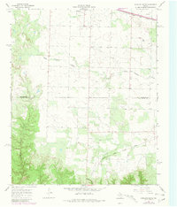
1967 Map of Kirkland South
USGS Topo · Published 1981About this map
Kirkland stands as the primary settlement in this corner of the Texas Panhandle, positioned near the northern border of the county line. The landscape is defined by the winding paths of South Groesbeck Creek and Raggedy Creek, which carve through the plains toward the Red River. This 1967 survey, updated with 1979 revisions, reveals a rural economy heavily dependent on the transport of goods, evidenced by the dual presence of the Fort Worth and Denver and the Quanah Acme and Pacific railroads.
Find a feature on this map
10 named features on this map. Tap any name to fly to it.
Don’t see what you’re looking for? This feature index may not catch every label — zoom into the map to look around manually.
Map Details
Editions of this 1967 Kirkland South Map
2 editions found
Other maps of this area

1927 · Quanah 3-b
USGS Topo · 1:48,000

1932 · Vivian
USGS Topo · 1:62,500

1954 · Plainview
USGS Topo · 1:250,000

1955 · Lawton
USGS Topo · 1:250,000

1958 · Plainview
USGS Topo · 1:250,000

1960 · Goodlett
USGS Topo · 1:62,500

1960 · Teacup Mountain
USGS Topo · 1:62,500

1967 · Buckle L Ranch
USGS Topo · 1:24,000

1967 · Kirkland South
USGS Topo · 1:24,000

1967 · Kirkland North
USGS Topo · 1:24,000