
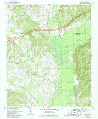
1965 Map of Kirkville
USGS Topo · Published 1966About this map
The Tombigbee River and its complex network of tributaries, including Twentymile Creek and Donivan Creek, define the topography of this Northeast Mississippi landscape. In the mid-1960s, the Natchez Trace Parkway was still marked as under construction as it cut through the county line between Prentiss and Itawamba. This era of modern infrastructure contrasts with the ancient history preserved at the Indian Mounds located near Big Brown Creek. For genealogists, the map is a dense record of rural community life, documenting small settlements like Kirkville and Marietta, alongside local landmarks such as Houston Sch and a cluster of denominational centers including Ozark Baptist Ch, Ozark Methodist Ch, and Ozark Church of Christ. The presence of a Gaging Station and named features like Ferguson Lake highlight the critical role of water management in this river-bottom territory.
Find a feature on this map
29 named features on this map. Tap any name to fly to it.
Don’t see what you’re looking for? This feature index may not catch every label — zoom into the map to look around manually.
Map Details
Editions of this 1965 Kirkville Map
2 editions found
Other maps of this area

1921 · Booneville
USGS Topo · 1:48,000

1921 · Tupelo
USGS Topo · 1:48,000

1922 · Booneville
USGS Topo · 1:62,500

1923 · Tupelo
USGS Topo · 1:62,500

1956 · Tupelo
USGS Topo · 1:250,000

1958 · Tupelo
USGS Topo · 1:250,000

1965 · Mooreville
USGS Topo · 1:24,000
1965 · Paden SE
USGS Topo · 1:24,000

1965 · Fulton SE
USGS Topo · 1:24,000

1965 · Fulton
USGS Topo · 1:24,000