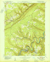
1950 Map of Kitzmiller
USGS Topo · Published 1950About this map
Backbone Mountain anchors this mid-century look at the borderlands of Maryland and West Virginia, where the Potomac River carves a deep valley between Garrett Co and Mineral Co. The industrial pulse of the region is evident in the proximity of Baltimore and Ohio and Western Maryland rail lines, which served the coal communities and strip mines dotting the hillsides. Settlement clusters tightly along the river and rail corridors, notably at Kitzmiller, Blaine, and Shaw.
Find a feature on this map
61 named features on this map. Tap any name to fly to it.
Don’t see what you’re looking for? This feature index may not catch every label — zoom into the map to look around manually.
Map Details
Editions of this 1950 Kitzmiller Map
3 editions found
Other maps of this area

1895 · Piedmont
USGS Topo · 1:125,000

1899 · Grantsville
USGS Topo · 1:62,500

1899 · Oakland
USGS Topo · 1:62,500

1900 · Accident
USGS Topo · 1:62,500

1900 · Oakland
USGS Topo · 1:62,500

1904 · Grantsville
USGS Topo · 1:62,500

1919 · Elk Garden
USGS Topo · 1:48,000

1920 · Elk Garden
USGS Topo · 1:48,000

1922 · Elk Garden
USGS Topo · 1:62,500
1947 · Barton
USGS Topo · 1:24,000