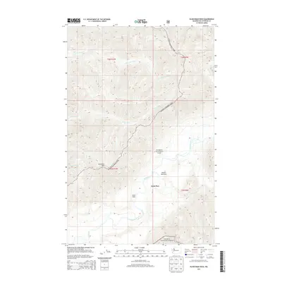
2014 Map of Kloochman Rock
USGS Topo · Published 2014About this map
Smith Place sits near the confluence of several vital waterways in this high-elevation corner of the Olympic Mountains. The landscape is dominated by the protected wilderness of Olympic National Park and Olympic National Forest, where the topography is shaped by the complex drainage systems of the Clearwater River and Queets River. For local historians and researchers, the map provides a precise look at the backcountry infrastructure of the early 21st century, including the Spruce Bottom Shelter and landmarks such as Kloochman Rock. The presence of named drainages like Tshletshy Cr, Stequaleho Cr, and Solleks River illustrates the rugged hydrological network that defines this part of Jefferson County.
Find a feature on this map
17 named features on this map. Tap any name to fly to it.
Don’t see what you’re looking for? This feature index may not catch every label — zoom into the map to look around manually.
Map Details
Editions of this 2014 Kloochman Rock Map
This is the sole edition of this map. No revisions or reprints were ever made.
Other maps of this area

1939 · Mount Tom
USGS Topo · 1:62,500

1943 · Spruce Mountain
USGS Topo · 1:62,500

1943 · Copalis Beach
USGS Topo · 1:250,000

1951 · Copalis Beach
USGS Topo · 1:250,000

1956 · Kloochman Rock
USGS Topo · 1:62,500

1956 · Mount Tom
USGS Topo · 1:62,500

1956 · Spruce Mtn.
USGS Topo · 1:62,500

1956 · Salmon River
USGS Topo · 1:62,500
1957 · Mount Tom
USGS Topo · 1:62,500

1957 · Copalis Beach
USGS Topo · 1:250,000