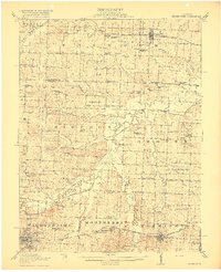
1917 Map of Knobnoster
USGS Topo · Published 1917About this map
Concordia and Knobnoster anchor a landscape defined by small rural school districts and the meandering Blackwater River during the late 1910s. This survey, conducted in cooperation with the State of Missouri, illustrates a dense network of one-room schoolhouses such as Hazel Bell School, Hepsidam School, and Victory School that served the farmsteads between Warrensburg and the Lafayette Co line. The Missouri Pacific railroad cuts through the southern tier, connecting the mining and timber interests of Montserrat to the larger rail corridor. The presence of numerous named branches like Cottonwood Branch and Blackjack Branch feeding into the Blackwater River reveals the complex drainage patterns of the central Missouri prairie. Small communities like Ernestville and Valley City appear as vital local hubs before the consolidation of rural infrastructure and the expansion of the regional highway system.
Find a feature on this map
67 named features on this map. Tap any name to fly to it.
Don’t see what you’re looking for? This feature index may not catch every label — zoom into the map to look around manually.
Map Details
Editions of this 1917 Knobnoster Map
3 editions found
Other maps of this area

1885 · Warrensburg
USGS Topo · 1:125,000

1887 · Sedalia
USGS Topo · 1:125,000

1887 · Warrensburg
USGS Topo · 1:125,000

1889 · Lexington
USGS Topo · 1:125,000

1890 · Marshall
USGS Topo · 1:125,000

1892 · Marshall
USGS Topo · 1:125,000

1894 · Sedalia
USGS Topo · 1:125,000

1894 · Warrensburg
USGS Topo · 1:125,000

1901 · Marshall
USGS Topo · 1:125,000

1917 · Knobnoster
USGS Topo · 1:62,500