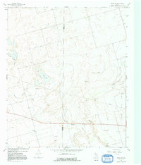
1966 Map of Knott SW
USGS Topo · Published 1991About this map
The boundary between Martin and Howard Counties divides this West Texas landscape, dominated by the active extraction of the Varel Oil Field. The terrain is defined by dramatic drainage patterns, most notably Sulphur Springs Draw and Buzzard Draw, which snake through the arid plains. In the central-west, Red Lake provides a distinct hydrological landmark amidst a grid of oil wells and drill holes.
Find a feature on this map
16 named features on this map. Tap any name to fly to it.
Don’t see what you’re looking for? This feature index may not catch every label — zoom into the map to look around manually.
Map Details
Editions of this 1966 Knott SW Map
2 editions found

Other maps of this area

1941 · Morita
USGS Topo · 1:62,500

1949 · Morita
USGS Topo · 1:62,500

1954 · Big Spring
USGS Topo · 1:250,000

1958 · Big Spring
USGS Topo · 1:250,000

1966 · Knott
USGS Topo · 1:24,000

1966 · Merrick
USGS Topo · 1:24,000

1966 · Natural Dam Lake
USGS Topo · 1:24,000

1966 · Knott SE
USGS Topo · 1:24,000
1966 · Elbow
USGS Topo · 1:24,000

1966 · Stanton
USGS Topo · 1:24,000