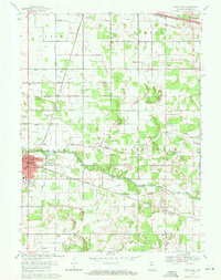
1969 Map of Knox East
USGS Topo · Published 1971About this map
The Yellow River winds through the heart of Starke County, anchoring a landscape defined by its intricate drainage network and the convergence of major rail lines. This 1969 revision details the expansion of Knox, the county seat, showing the development of Sandy Acres Park and the County Airport alongside established institutions like Crown Hill Cem and St Thomas Sch. The surrounding rural townships of Oregon, Washington, and Center are stitched together by the Penn Central railroad, which services smaller settlements such as Grovertown, Hamlet, and Ober. Genealogists will find significant value in the numerous family and parish burial grounds, including Swartzell Cem, Oak Grove Cem, and Fletcher Cem, while the vast system of man-made waterways like Bailey Ditch and Cox Ditch illustrates the era's intensive agricultural land management.
Find a feature on this map
57 named features on this map. Tap any name to fly to it.
Don’t see what you’re looking for? This feature index may not catch every label — zoom into the map to look around manually.
Map Details
Editions of this 1969 Knox East Map
2 editions found
Other maps of this area

1953 · Chicago
USGS Topo · 1:250,000

1957 · Chicago
USGS Topo · 1:250,000

1957 · Knox East
USGS Topo · 1:24,000

1957 · Knox West
USGS Topo · 1:24,000

1958 · Donaldson
USGS Topo · 1:24,000

1958 · Kingsford Heights
USGS Topo · 1:24,000

1958 · Hamlet
USGS Topo · 1:24,000

1958 · Walkerton
USGS Topo · 1:24,000

1962 · Denham
USGS Topo · 1:24,000

1962 · Bass Lake
USGS Topo · 1:24,000