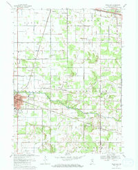
1969 Map of Knox East
USGS Topo · Published 1971About this map
The Yellow River winds through the heart of Starke County, anchoring a landscape defined by its agricultural drainage network and early rail corridors. The city of Knox serves as the regional hub, where the Penn Central and Norfolk and Western railroads intersect near the Knox City Hall. This 1969 survey captures the community's infrastructure at its post-war peak, including the County Airport and Sandy Acres Park on the southern edge of town.
Find a feature on this map
49 named features on this map. Tap any name to fly to it.
Don’t see what you’re looking for? This feature index may not catch every label — zoom into the map to look around manually.
Map Details
Editions of this 1969 Knox East Map
2 editions found
Other maps of this area

1953 · Chicago
USGS Topo · 1:250,000

1957 · Chicago
USGS Topo · 1:250,000

1957 · Knox East
USGS Topo · 1:24,000

1957 · Knox West
USGS Topo · 1:24,000

1958 · Donaldson
USGS Topo · 1:24,000

1958 · Kingsford Heights
USGS Topo · 1:24,000

1958 · Hamlet
USGS Topo · 1:24,000

1958 · Walkerton
USGS Topo · 1:24,000

1962 · Denham
USGS Topo · 1:24,000

1962 · Bass Lake
USGS Topo · 1:24,000