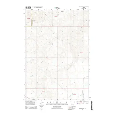
2014 Map of Knudson Draw
USGS Topo · Published 2014About this map
Selway Spring and Church Spring mark reliable water sources in the semi-arid grasslands along the border of Powder River and Carter counties. The landscape is defined by an intricate network of drainages and named coulees, including Quaking Aspen Draw, Pentecost Draw, and the namesake Knudson Draw. These landforms funnel seasonal runoff into larger watercourses like Crow Cr and the W Fork Boxelder Cr. The road network is sparse, centered on the gravel routes of Crow Creek Rd and Hammond Rd, while Us-212 cuts across the southwestern corner. This topography illustrates the ranching-dependent layout of southeastern Montana, where life and transit are dictated by the deep incisions of Kuster Canyon and the availability of groundwater in an otherwise high-plains environment.
Find a feature on this map
16 named features on this map. Tap any name to fly to it.
Don’t see what you’re looking for? This feature index may not catch every label — zoom into the map to look around manually.
Map Details
Editions of this 2014 Knudson Draw Map
This is the sole edition of this map. No revisions or reprints were ever made.
Other maps of this area

1954 · Ekalaka
USGS Topo · 1:250,000

1956 · Ekalaka
USGS Topo · 1:250,000

1958 · Ekalaka
USGS Topo · 1:250,000

1965 · Ekalaka
USGS Topo · 1:250,000
1970 · Belle Creek North
USGS Topo · 1:24,000
1970 · Hammond
USGS Topo · 1:24,000
1970 · Greasy Hill
USGS Topo · 1:24,000

1980 · Broadus
USGS Topo · 1:100,000

1981 · Alzada
USGS Topo · 1:100,000

1982 · Phillippi Reservoir
USGS Topo · 1:24,000