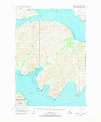
1949 Map of Kodiak B-3
USGS Topo · Published 1973About this map
Kodiak Island industry and coastal geography are the focus of this 1949 survey, which captures the maritime infrastructure of the central-east coast. The Kodiak Fisheries Cannery and an adjacent Seaplane Base on Shearwater Bay represent the economic drivers of the era, while the label for Eagle Harbor (Aban'd) on the north shore of the island marks a shift in local settlement patterns.
Find a feature on this map
24 named features on this map. Tap any name to fly to it.
Don’t see what you’re looking for? This feature index may not catch every label — zoom into the map to look around manually.
Map Details
Editions of this 1949 Kodiak B-3 Map
3 editions found
Other maps of this area

1949 · Kodiak C-2
USGS Topo · 1:63,360

1949 · Kodiak B-1 and B-2
USGS Topo · 1:63,360

1949 · Kodiak A-3
USGS Topo · 1:63,360

1949 · Kodiak B-3
USGS Topo · 1:63,360

1950 · Kodiak A-3
USGS Topo · 1:63,360

1950 · Kodiak B-3
USGS Topo · 1:63,360

1951 · Kodiak B-1 and B-2
USGS Topo · 1:63,360

1952 · Kodiak
USGS Topo · 1:250,000

1952 · Kodiak C-3
USGS Topo · 1:63,360

1952 · Kodiak C-4
USGS Topo · 1:63,360