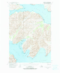
1949 Map of Kodiak B-3
USGS Topo · Published 1984About this map
The industrial and maritime activity of mid-century Kodiak Island is concentrated along the deeply recessed shoreline of Shearwater Bay, where the Kodiak Fisheries Cannery and a dedicated Seaplane Base served the region's commercial fishing fleet. The complex coastline is defined by several major inlets, including Ugak Bay to the north and the expansive Kiliuda Bay to the south. While much of the interior is dominated by high, unnamed peaks, specific coastal landmarks like Observation Point and Pillar Point provided essential navigation for vessels moving toward the Gulf of Alaska. Signs of shifting settlement patterns appear at Eagle Harbor (Aband), reflecting the ephemeral nature of remote outposts in this era. The southwestern portion of the map encompasses protected lands within the Kodiak National Wildlife Refuge, indicating the early establishment of conservation boundaries in the territory.
Find a feature on this map
50 named features on this map. Tap any name to fly to it.
Don’t see what you’re looking for? This feature index may not catch every label — zoom into the map to look around manually.
Map Details
Editions of this 1949 Kodiak B-3 Map
3 editions found
Other maps of this area

1949 · Kodiak C-2
USGS Topo · 1:63,360

1949 · Kodiak B-1 and B-2
USGS Topo · 1:63,360

1949 · Kodiak A-3
USGS Topo · 1:63,360

1949 · Kodiak B-3
USGS Topo · 1:63,360

1950 · Kodiak A-3
USGS Topo · 1:63,360

1950 · Kodiak B-3
USGS Topo · 1:63,360

1951 · Kodiak B-1 and B-2
USGS Topo · 1:63,360

1952 · Kodiak
USGS Topo · 1:250,000

1952 · Kodiak C-3
USGS Topo · 1:63,360

1952 · Kodiak C-4
USGS Topo · 1:63,360