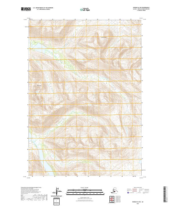
2021 Map of Kodiak B-6 SW
USGS Topo · Published 2021About this map
Kodiak Island's interior reveals a dense network of glacial waters and high peaks in this recent topographic study. The landscape is defined by the significant basin of Karluk Lake in the southwest, which feeds the O'Malley River as it connects from O'Malley Lake. Dominating the western heights, Mt Shuman stands as a primary landmark overlooking the drainages of Salmon Cr and the various branches of the Thumb River system. The intricate hydrology, including the N Fork Thumb River and E Fork Thumb River, suggests a high-energy drainage environment where water moves rapidly from the surrounding ridges into Thumb Lake. This map captures a pristine wilderness area, showing the precise relationship between the high alpine summits and the interconnected river systems that define this part of the island.
Find a feature on this map
18 named features on this map. Tap any name to fly to it.
Don’t see what you’re looking for? This feature index may not catch every label — zoom into the map to look around manually.
Map Details
Editions of this 2021 Kodiak B-6 SW Map
This is the sole edition of this map. No revisions or reprints were ever made.
Other maps of this area

1951 · Karluk
USGS Topo · 1:250,000

1952 · Kodiak
USGS Topo · 1:250,000

1952 · Karluk
USGS Topo · 1:250,000

1952 · Kodiak B-6
USGS Topo · 1:63,360

1952 · Karluk B-1
USGS Topo · 1:63,360

1952 · Karluk A-1
USGS Topo · 1:63,360

1952 · Kodiak A-6
USGS Topo · 1:63,360
1954 · Karluk A-1
USGS Topo · 1:63,360
1954 · Karluk B-1
USGS Topo · 1:63,360
1954 · Kodiak A-6
USGS Topo · 1:63,360