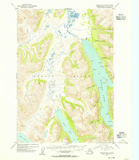
1954 Map of Karluk B-1
USGS Topo · Published 1955About this map
Karluk Lake dominates this interior portion of Kodiak Island, a region defined by its significant glacial lakes and complex drainage systems in the mid-1950s. The northern end of the lake is marked by human activity at Cabins, where the Karluk River begins its northward flow. Further south, Frazer Lake and Red Lake provide a detailed look at the island's freshwater geography. The eastern shore of Karluk Lake is particularly articulated, featuring numerous named landmarks such as Boulder Pt, Bear Pt, and Tree Pt, while the western side is fed by Halfway Creek.
Find a feature on this map
28 named features on this map. Tap any name to fly to it.
Don’t see what you’re looking for? This feature index may not catch every label — zoom into the map to look around manually.
Map Details
Editions of this 1954 Karluk B-1 Map
This is the sole edition of this map. No revisions or reprints were ever made.
Other maps of this area

1951 · Karluk
USGS Topo · 1:250,000

1952 · Kodiak
USGS Topo · 1:250,000

1952 · Karluk
USGS Topo · 1:250,000

1952 · Karluk C-2
USGS Topo · 1:63,360

1952 · Karluk B-2
USGS Topo · 1:63,360

1952 · Kodiak B-6
USGS Topo · 1:63,360

1952 · Karluk B-1
USGS Topo · 1:63,360

1952 · Karluk C-1
USGS Topo · 1:63,360

1952 · Kodiak C-6
USGS Topo · 1:63,360

1952 · Karluk A-1
USGS Topo · 1:63,360