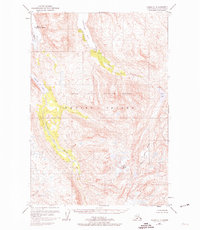
1952 Map of Kodiak C-4
USGS Topo · Published 1974About this map
Port O'Brien stands as the primary outpost on this mid-century survey of Kodiak Island, established at the edge of the deep waters of Terror Bay. The landscape is dominated by the Kodiak National Wildlife Refuge, where the high peaks of Mount Glottof oversee a network of glacial lakes and rivers. This area represents a critical intersection of maritime utility and wilderness preservation, illustrated by the co-location of a Seaplane Base and Fuel Tanks near the settlement.
Find a feature on this map
14 named features on this map. Tap any name to fly to it.
Don’t see what you’re looking for? This feature index may not catch every label — zoom into the map to look around manually.
Map Details
Editions of this 1952 Kodiak C-4 Map
4 editions found
Other maps of this area

1947 · Kodiak D-3
USGS Topo · 1:63,360

1949 · Kodiak D-3
USGS Topo · 1:63,360

1949 · Kodiak B-3
USGS Topo · 1:63,360

1950 · Kodiak B-3
USGS Topo · 1:63,360

1950 · Kodiak D-3
USGS Topo · 1:63,360

1952 · Kodiak
USGS Topo · 1:250,000

1952 · Kodiak C-3
USGS Topo · 1:63,360

1952 · Kodiak C-4
USGS Topo · 1:63,360

1952 · Kodiak C-5
USGS Topo · 1:63,360

1952 · Kodiak D-5
USGS Topo · 1:63,360