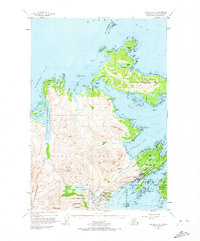
1949 Map of Kodiak D-2
USGS Topo · Published 1973About this map
Kodiak Island reveals its rugged coastline and strategic maritime positioning in the late 1940s, a period marked by the significant presence of the U S Naval Reservation along the southern coastline. The settlement of Kodiak serves as the hub of activity, supported by the Municipal Airport and a nearby Seaplane Base, illustrating the area's reliance on air and sea transport. To the north, the village of Ouzinkie sits on Spruce Island overlooking the Ouzinkie Narrows, guarded by Ouzinkie Light. The landscape is dominated by high peaks like Mount Herman and Pyramid Mountain, while the intricate shoreline is dotted with numerous islands such as Woody Island and Near Island. This map documents a transitional era when coastal defenses and maritime industries shaped the development of these Alaskan island communities.
Find a feature on this map
89 named features on this map. Tap any name to fly to it.
Don’t see what you’re looking for? This feature index may not catch every label — zoom into the map to look around manually.
Map Details
Editions of this 1949 Kodiak D-2 Map
5 editions found
Other maps of this area

1947 · Kodiak D-3
USGS Topo · 1:63,360

1949 · Kodiak C-2
USGS Topo · 1:63,360

1949 · Kodiak D-2
USGS Topo · 1:63,360

1949 · Kodiak D-3
USGS Topo · 1:63,360

1949 · Kodiak C-1
USGS Topo · 1:63,360

1949 · Kodiak D-1
USGS Topo · 1:63,360

1950 · Kodiak D-3
USGS Topo · 1:63,360

1951 · Kodiak D-1
USGS Topo · 1:63,360

1951 · Kodiak D-2
USGS Topo · 1:63,360

1951 · Kodiak C-1
USGS Topo · 1:63,360