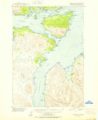
1950 Map of Kodiak D-3
USGS Topo · Published 1950About this map
Whale Island and the surrounding straits form the center of this coastal study, illustrating the complex maritime geography of the northern Kodiak archipelago. Surveyed just after the war, the map details the critical waterways of Kupreanof Strait and Afognak Strait, which served as vital corridors for coastal navigation. The terrain is marked by deep inlets like Kizhuyak Bay and Sharatin Bay, where names like Settler Cove and Barabara Cove hint at the human history of the shoreline. To the north, the boundary of the Chugach National Forest encompasses Raspberry Island and several smaller landmasses like Little Raspberry Island. The intricate coastline is meticulously charted, featuring numerous points such as Nochlega Point and Chernof Point, which provided essential landmarks for the fishing and transport vessels of the mid-century era.
Find a feature on this map
58 named features on this map. Tap any name to fly to it.
Don’t see what you’re looking for? This feature index may not catch every label — zoom into the map to look around manually.
Map Details
Editions of this 1950 Kodiak D-3 Map
2 editions found
Other maps of this area

1947 · Kodiak D-3
USGS Topo · 1:63,360

1949 · Kodiak C-2
USGS Topo · 1:63,360

1949 · Kodiak D-2
USGS Topo · 1:63,360

1949 · Kodiak D-3
USGS Topo · 1:63,360

1950 · Kodiak D-3
USGS Topo · 1:63,360

1951 · Kodiak D-2
USGS Topo · 1:63,360

1952 · Kodiak
USGS Topo · 1:250,000

1952 · Afognak
USGS Topo · 1:250,000

1952 · Kodiak C-3
USGS Topo · 1:63,360

1952 · Afognak A-4
USGS Topo · 1:63,360