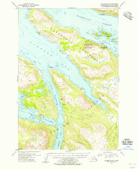
1954 Map of Kodiak D-4
USGS Topo · Published 1955About this map
Port Bailey Cannery stands as a focal point of coastal industry on the Kupreanof Peninsula, where the maritime economy of the mid-1950s is etched into the shoreline of Dry Spruce Bay. This maritime landscape is defined by its deep saltwater inlets and narrow passages, such as Uganik Passage, which separates Uganik Island from the larger mass of Kodiak Island. The topography reveals a rugged interior where heights like Kupreanof Mountain overlook Kupreanof Strait and Viekoda Bay. Evidence of earlier resource extraction is noted at a Mine (Aban'd) near Rolling Pt, while scattered Cabins and a secondary Cannery at the southern edge of the map suggest the seasonal and isolated nature of life along these shores. The presence of Raspberry Island to the north and Terror Bay to the south highlights the complex network of islands and sounds that dictated local travel and commerce.
Find a feature on this map
26 named features on this map. Tap any name to fly to it.
Don’t see what you’re looking for? This feature index may not catch every label — zoom into the map to look around manually.
Map Details
Editions of this 1954 Kodiak D-4 Map
This is the sole edition of this map. No revisions or reprints were ever made.
Other maps of this area

1947 · Kodiak D-3
USGS Topo · 1:63,360

1949 · Kodiak D-3
USGS Topo · 1:63,360

1950 · Kodiak D-3
USGS Topo · 1:63,360

1952 · Kodiak
USGS Topo · 1:250,000

1952 · Afognak
USGS Topo · 1:250,000

1952 · Kodiak C-3
USGS Topo · 1:63,360

1952 · Afognak A-4
USGS Topo · 1:63,360

1952 · Kodiak C-4
USGS Topo · 1:63,360

1952 · Kodiak C-5
USGS Topo · 1:63,360

1952 · Kodiak D-5
USGS Topo · 1:63,360