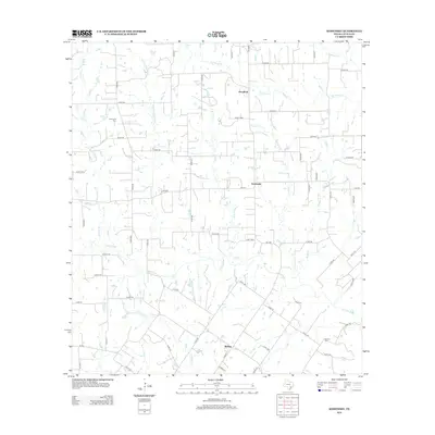
2013 Map of Komensky
USGS Topo · Published 2013About this map
The Lavaca River and its numerous tributaries, including the N Fork Lavaca River and Liveoak Cr, define the rural landscape of this central Texas region. Settled areas are scattered among the waterways, with Komensky serving as a central point in the quadrangle. The map documents several small, localized communities such as Novohrad to the north and Witting to the south, connected by a network of farm roads like FM 340.
Find a feature on this map
69 named features on this map. Tap any name to fly to it.
Don’t see what you’re looking for? This feature index may not catch every label — zoom into the map to look around manually.
Map Details
Editions of this 2013 Komensky Map
This is the sole edition of this map. No revisions or reprints were ever made.
Other maps of this area

1901 · Flatonia
USGS Topo · 1:125,000

1919 · Schulenburg
USGS Topo · 1:62,500

1953 · Seguin
USGS Topo · 1:250,000

1958 · Seguin
USGS Topo · 1:250,000

1962 · Hallettsville
USGS Topo · 1:24,000

1965 · Schulenburg
USGS Topo · 1:24,000

1965 · Wied
USGS Topo · 1:24,000

1965 · Komensky
USGS Topo · 1:24,000
1965 · Moravia
USGS Topo · 1:24,000

1965 · Flatonia
USGS Topo · 1:24,000