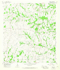
1965 Map of Moravia
USGS Topo · Published 1967About this map
Moravia sits atop the rolling divide between the Navidad River and the Lavaca River in this mid-1960s survey of the Fayette and Lavaca County borderlands. The landscape is defined by its rural social centers and creek-bottom drainage, notably the Old Kinkler Community Hall and several scattered rural churches such as Willow Spring Ch and St Paul Ch. This era shows a community still deeply rooted in its nineteenth-century foundations, with family and community legacy preserved in sites like the Andrew Chapel Cem and Williams Cem. The map provides a detailed view of the terrain around Appelt Hill and the numerous named watercourses, including Big Rocky Creek and Mule Spring Branch, that carved out the local agricultural economy. Small clusters of settlement at Breslau, Kinkler, and Mixon illustrate the dispersed yet interconnected nature of central Texas farm life before the significant modern consolidation of these rural areas.
Find a feature on this map
31 named features on this map. Tap any name to fly to it.
Don’t see what you’re looking for? This feature index may not catch every label — zoom into the map to look around manually.
Map Details
Editions of this 1965 Moravia Map
2 editions found
Other maps of this area

1901 · Flatonia
USGS Topo · 1:125,000

1919 · Schulenburg
USGS Topo · 1:62,500

1953 · Seguin
USGS Topo · 1:250,000

1958 · Seguin
USGS Topo · 1:250,000

1962 · Sublime
USGS Topo · 1:24,000

1962 · Hallettsville
USGS Topo · 1:24,000

1965 · Oakland
USGS Topo · 1:24,000
1965 · Weimar
USGS Topo · 1:24,000

1965 · Schulenburg
USGS Topo · 1:24,000

1965 · Wied
USGS Topo · 1:24,000