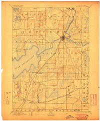
1894 Map of Koshkonong
USGS Topo · Published 1903About this map
Lake Koshkonong dominates the center of this late 19th-century landscape, surrounded by a complex network of glacial drumlins and wetlands that dictated early Wisconsin settlement patterns. The Rock River flows southward through Jefferson and Fort Atkinson, serving as a primary corridor for transportation and industry alongside the Chicago and North Western Railroad. This survey, conducted by Van H. Manning Jr. and I.M. Buell, captures the region just as the rail lines were solidifying the importance of hubs like Milton Junction and Milton. Smaller hamlets such as Busseyville and Cold Spring appear as distinct rural centers, while the intricate hydrography of Oakland Creek and Bark River highlights the transition from natural prairie and timber to organized agricultural townships.
Find a feature on this map
27 named features on this map. Tap any name to fly to it.
Don’t see what you’re looking for? This feature index may not catch every label — zoom into the map to look around manually.
Map Details
Editions of this 1894 Koshkonong Map
2 editions found

Other maps of this area

1890 · Sun Prairie
USGS Topo · 1:62,500

1890 · Stoughton
USGS Topo · 1:62,500

1891 · Waterloo
USGS Topo · 1:62,500

1891 · Koshkonong
USGS Topo · 1:62,500

1891 · Janesville
USGS Topo · 1:62,500

1892 · Watertown
USGS Topo · 1:62,500

1892 · Whitewater
USGS Topo · 1:62,500

1893 · Delavan
USGS Topo · 1:62,500

1893 · Whitewater
USGS Topo · 1:62,500

1893 · Janesville
USGS Topo · 1:62,500