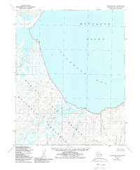
1950 Map of Kotzebue A-4
USGS Topo · Published 1988About this map
The Bering Land Bridge National Preserve encompasses much of this coastal landscape, protecting a region of immense significance for understanding the migration of early peoples. Mapped from aerial photography taken in 1949 and 1950, the sheet documents the intricate shoreline where Kotzebue Sound meets Goodhope Bay. The low-lying terrain is defined by a complex network of waterways, including the meandering Pish River and the Goodhope River, which empty into the bay amidst a series of tidal flats and coastal lagoons.
Find a feature on this map
10 named features on this map. Tap any name to fly to it.
Don’t see what you’re looking for? This feature index may not catch every label — zoom into the map to look around manually.
Map Details
Editions of this 1950 Kotzebue A-4 Map
3 editions found
Other maps of this area

1950 · Bendeleben D-5
USGS Topo · 1:63,360

1950 · Bendeleben
USGS Topo · 1:250,000

1950 · Bendeleben D-3
USGS Topo · 1:63,360

1950 · Bendeleben D-4
USGS Topo · 1:63,360

1950 · Kotzebue B-4
USGS Topo · 1:63,360

1950 · Kotzebue B-5
USGS Topo · 1:63,360

1950 · Kotzebue A-4
USGS Topo · 1:63,360

1950 · Kotzebue A-5
USGS Topo · 1:63,360

1950 · Kotzebue A-3
USGS Topo · 1:63,360

1951 · Bendeleben
USGS Topo · 1:250,000