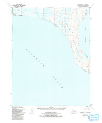
1951 Map of Kotzebue C-1
USGS Topo · Published 1991About this map
Baldwin Peninsula dominates this coastal survey, stretching between the expansive Kotzebue Sound and Hotham Inlet. The topography is defined by the marshy, low-lying character of the Arctic coastline, dotted with numerous small thaw lakes and coastal features like Cape Blossom. A solitary Cabin and a Light are the only signs of structural habitation, reflecting the isolated nature of this region before extensive modern development.
Find a feature on this map
9 named features on this map. Tap any name to fly to it.
Don’t see what you’re looking for? This feature index may not catch every label — zoom into the map to look around manually.
Map Details
Editions of this 1951 Kotzebue C-1 Map
3 editions found
Other maps of this area

1951 · Selawik
USGS Topo · 1:250,000

1951 · Kotzebue
USGS Topo · 1:250,000

1951 · Kotzebue D-1
USGS Topo · 1:63,360

1951 · Selawik C-6
USGS Topo · 1:63,360

1951 · Selawik B-6
USGS Topo · 1:63,360

1951 · Kotzebue D-2
USGS Topo · 1:63,360

1951 · Selawik D-6
USGS Topo · 1:63,360
1951 · Kotzebue C-1
USGS Topo · 1:63,360

1952 · Selawik D-6
USGS Topo · 1:63,360

1957 · Selawik
USGS Topo · 1:250,000