
1951 Map of Kotzebue D-1
USGS Topo · Published 1957About this map
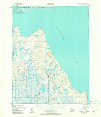
The Baldwin Peninsula dominates this coastal survey, where the rugged terrain of northwest Alaska meets the expansive Hotham Inlet. Surveyed in the early 1950s using aerial photography, the map reveals a landscape defined by intricate drainage patterns and thousands of small tundra ponds. To the north, the massive Noatak River Delta enters the sea, forming a complex network of marshes and shifting channels.
Find a feature on this map
5 named features on this map. Tap any name to fly to it.
Don’t see what you’re looking for? This feature index may not catch every label — zoom into the map to look around manually.
Map Details
Editions of this 1951 Kotzebue D-1 Map
2 editions found
Other maps of this area

1951 · Baird Mountains
USGS Topo · 1:250,000

1951 · Selawik
USGS Topo · 1:250,000

1951 · Noatak
USGS Topo · 1:250,000

1951 · Kotzebue
USGS Topo · 1:250,000

1951 · Selawik C-6
USGS Topo · 1:63,360

1951 · Kotzebue D-2
USGS Topo · 1:63,360

1951 · Selawik D-6
USGS Topo · 1:63,360
1951 · Kotzebue C-1
USGS Topo · 1:63,360

1952 · Selawik D-6
USGS Topo · 1:63,360

1955 · Noatak
USGS Topo · 1:250,000