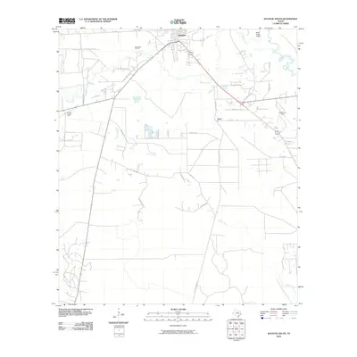
2010 Map of Kountze South
USGS Topo · Published 2010About this map
Kountze serves as the focal point of this Hardin County landscape, situated at a junction of rail and road where the local timber and petroleum legacy remains visible. The presence of the Nona Mills Oil Field and the small settlement of Nona south of the city center point to a history of resource extraction in the East Texas Piney Woods. In the surrounding woodlands, the Kountze Lookout Tower stands near Cypress Creek, a reminder of the vigilance required in this heavily forested timberland. To the east, the terrain is shaped by the winding course of Village Creek and the subtle rise of Bear Grass Ridge. A network of local rural routes, including Old Cemetery Rd and Sapp Graveyard Rd, provides points of interest for those tracing family history and old land tracts through the thickets and creek bottoms of the Big Thicket region.
Find a feature on this map
31 named features on this map. Tap any name to fly to it.
Don’t see what you’re looking for? This feature index may not catch every label — zoom into the map to look around manually.
Map Details
Editions of this 2010 Kountze South Map
This is the sole edition of this map. No revisions or reprints were ever made.
Other maps of this area

1932 · Beaumont
USGS Topo · 1:62,500

1954 · Beaumont
USGS Topo · 1:250,000

1955 · Silsbee
USGS Topo · 1:62,500

1955 · Kountze
USGS Topo · 1:62,500

1955 · Sour Lake
USGS Topo · 1:62,500

1957 · Beaumont
USGS Topo · 1:250,000
1960 · Voth
USGS Topo · 1:24,000

1984 · Beaumont
USGS Topo · 1:250,000

1984 · Sour Lake
USGS Topo · 1:24,000
1984 · Bevil Oaks
USGS Topo · 1:24,000