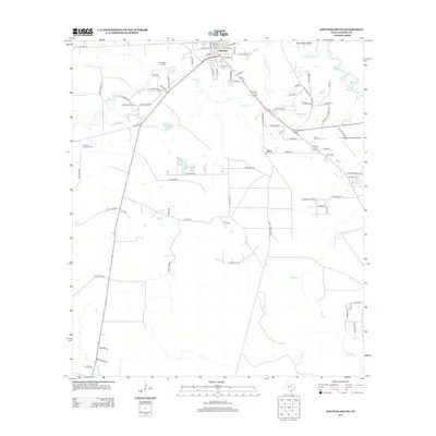
2013 Map of Kountze South
USGS Topo · Published 2013About this map
Kountze serves as the focal point for this Southeast Texas landscape, where residential streets like Main St and Hodges St give way to a network of drainage systems and industrial landmarks. The southern outskirts of the town are defined by the winding course of Cypress Cr, which flows eastward toward Village Cr near the northern boundary. Industrial activity is evident at the Nona Mills Oil Field, reflecting the region's long-standing connection to the petroleum sector. To the south, the settlement of Nona sits along the roadway, while the Kountze Lookout Tower and Hawthorne Field Airport anchor the western and eastern portions of the map respectively. This survey illustrates how contemporary infrastructure, including Fire Tower Rd and Camp Wheeler Rd, overlays a terrain characterized by ridges like Bear Grass Ridge and numerous creek branches such as Longston Br.
Find a feature on this map
82 named features on this map. Tap any name to fly to it.
Don’t see what you’re looking for? This feature index may not catch every label — zoom into the map to look around manually.
Map Details
Editions of this 2013 Kountze South Map
This is the sole edition of this map. No revisions or reprints were ever made.
Other maps of this area

1932 · Beaumont
USGS Topo · 1:62,500

1954 · Beaumont
USGS Topo · 1:250,000

1955 · Silsbee
USGS Topo · 1:62,500

1955 · Kountze
USGS Topo · 1:62,500

1955 · Sour Lake
USGS Topo · 1:62,500

1957 · Beaumont
USGS Topo · 1:250,000
1960 · Voth
USGS Topo · 1:24,000

1984 · Beaumont
USGS Topo · 1:250,000

1984 · Sour Lake
USGS Topo · 1:24,000
1984 · Bevil Oaks
USGS Topo · 1:24,000