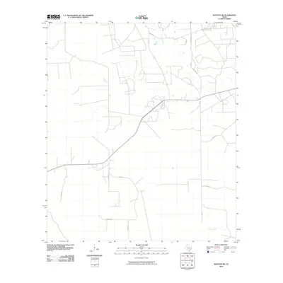
2010 Map of Kountze SW
USGS Topo · Published 2010About this map
Cypress Creek meanders through the northern reaches of this Hardin County landscape, defining the local drainage patterns alongside Black Creek to the south. The area is characterized by a sparse network of rural routes and family-named thoroughfares, reflecting a settlement pattern focused on landownership and agricultural access. Notable among these are Sam Brown Rd, W Nona Rd, and Little Rock Rd, which connect various parcels across the terrain. The presence of Cash Rd and Matthews Ln further illustrates the localized, residential nature of the infrastructure at this time. This 2010 survey provides a detailed view of the rural development southeast of the Big Thicket region, where the grid of county roads like Gannon Rd and Hatcher Rd intersects with the natural watercourses of east Texas.
Find a feature on this map
13 named features on this map. Tap any name to fly to it.
Don’t see what you’re looking for? This feature index may not catch every label — zoom into the map to look around manually.
Map Details
Editions of this 2010 Kountze SW Map
This is the sole edition of this map. No revisions or reprints were ever made.
Other maps of this area

1943 · Liberty
USGS Topo · 1:125,000

1954 · Beaumont
USGS Topo · 1:250,000

1955 · Daisetta
USGS Topo · 1:62,500

1955 · Saratoga
USGS Topo · 1:62,500

1955 · Kountze
USGS Topo · 1:62,500

1955 · Sour Lake
USGS Topo · 1:62,500

1957 · Beaumont
USGS Topo · 1:250,000

1984 · Beaumont
USGS Topo · 1:250,000

1984 · Sour Lake
USGS Topo · 1:24,000
1984 · Bevil Oaks
USGS Topo · 1:24,000