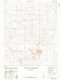
1947 Map of Kramer SW
USGS Topo · Published 1961About this map
The Muroc Army Airfield Military Reservation dominates the northern landscape of this 1947 survey, a time when the high desert was becoming a critical hub for Cold War aeronautical testing. This transition from a sparsely settled basin to a military corridor is etched into the terrain of the Antelope Valley and the western reaches of the Mojave Desert. The map captures the geometric precision of the growing desert grid, with arterial routes like Avenue D and Avenue E beginning to structure the valley floor. To the south, the terrain descends into Mirage Valley, while landmarks like Jackrabbit Hill provide rare vertical relief in an otherwise expansive, level basin. This military edition, compiled from 1946 aerial photography, preserves the early footprint of defense infrastructure that would eventually evolve into Edwards Air Force Base.
Find a feature on this map
8 named features on this map. Tap any name to fly to it.
Don’t see what you’re looking for? This feature index may not catch every label — zoom into the map to look around manually.
Map Details
Editions of this 1947 Kramer SW Map
3 editions found
Other maps of this area

1931 · Adobe
USGS Topo · 1:24,000

1931 · Hi Vista
USGS Topo · 1:24,000

1934 · Adobe
USGS Topo · 1:24,000

1935 · Hi Vista
USGS Topo · 1:24,000

1937 · Shadow Mountains
USGS Topo · 1:48,000

1937 · Kramer
USGS Topo · 1:48,000

1937 · Rogers Lake
USGS Topo · 1:48,000

1942 · Kramer
USGS Topo · 1:62,500

1942 · Shadow Mountains
USGS Topo · 1:62,500

1942 · Rogers Lake
USGS Topo · 1:62,500