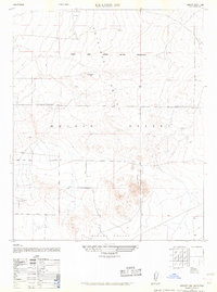
1947 Map of Kramer SW
USGS Topo · Published 1961About this map
Muroc Army Airfield Military Reservation dominates the northern expanse of this landscape, reflecting the intensive military expansion within the Mojave Desert during and immediately after World War II. Compiled by the Army Map Service using 1946 aerial photography, the map documents a transition from open desert terrain to a controlled defense landscape. Prominent landmarks such as Jackrabbit Hill rise above the alluvial plains, while the broad reaches of the Antelope Valley and Mirage Valley define the regional geography. The presence of a simple, straight road labeled Avenue cutting through the southern half suggests the early, rigid grid of desert development, providing a stark contrast to the undeveloped terrain of the military target areas to the north.
Find a feature on this map
9 named features on this map. Tap any name to fly to it.
Don’t see what you’re looking for? This feature index may not catch every label — zoom into the map to look around manually.
Map Details
Editions of this 1947 Kramer SW Map
3 editions found
Other maps of this area

1931 · Adobe
USGS Topo · 1:24,000

1931 · Hi Vista
USGS Topo · 1:24,000

1934 · Adobe
USGS Topo · 1:24,000

1935 · Hi Vista
USGS Topo · 1:24,000

1937 · Shadow Mountains
USGS Topo · 1:48,000

1937 · Kramer
USGS Topo · 1:48,000

1937 · Rogers Lake
USGS Topo · 1:48,000

1942 · Kramer
USGS Topo · 1:62,500

1942 · Shadow Mountains
USGS Topo · 1:62,500

1942 · Rogers Lake
USGS Topo · 1:62,500