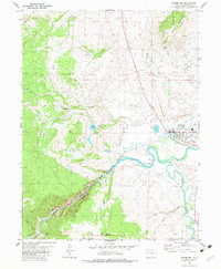
1981 Map of Kremmling
USGS Topo · Published 1983About this map
Kremmling stands at the confluence of several significant waterways, where the Colorado River meets the Blue River and Muddy Creek. By the early 1980s, the town's infrastructure included the West Grand High Sch, a local Airport, and a Fairground, reflecting its role as a regional hub in Grand County. The Denver and Rio Grande Western railroad tracks follow the winding path of the Colorado River through the narrow, steep-walled Gore Canyon, passing landmarks like Inspiration Point. This terrain showcases a complex drainage system, from high-altitude reservoirs like City Reservoir and Kids Pond to the low-lying Alkali Slough and Burke Slough. The convergence of these rivers and the rail line underscores the historical importance of this mountain valley for both transportation and water management.
Find a feature on this map
32 named features on this map. Tap any name to fly to it.
Don’t see what you’re looking for? This feature index may not catch every label — zoom into the map to look around manually.
Map Details
Editions of this 1981 Kremmling Map
2 editions found
Other maps of this area

1933 · Mt. Powell
USGS Topo · 1:48,000

1940 · Mount Powell
USGS Topo · 1:62,500

1954 · Craig
USGS Topo · 1:250,000

1956 · Kremmling
USGS Topo · 1:62,500

1956 · Gore Pass
USGS Topo · 1:62,500

1957 · Craig
USGS Topo · 1:250,000

1957 · Leadville
USGS Topo · 1:250,000

1958 · Craig
USGS Topo · 1:250,000

1959 · Leadville
USGS Topo · 1:250,000

1960 · Leadville
USGS Topo · 1:250,000