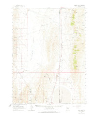
1964 Map of Kumiva Peak
USGS Topo · Published 1975About this map
The San Emidio Desert and northern reaches of the Lake Range dominate this mid-century desert survey, revealing a landscape of extreme aridity and scattered hydrological points. The map spans the border of Washoe and Pershing counties, centered on the high peaks of the Selenite Range, including Kumiva Peak and the evocatively named Mt Limbo. Signs of human presence are sparse, concentrated around water sources and small-scale resource extraction, such as the Cowles Ranch near Meadow Creek and various Gravel Pits and Quarries along the eastern valley. Cultural significance is noted at the Indian Caves on the slopes of Falcon Hill, while the western edge of the quadrangle marks the boundary of the Pyramid Lake Indian Reservation. The southern portion of the map covers the dry bed of Winnemucca Lake, highlighting the transient nature of water in this basin and range province.
Find a feature on this map
49 named features on this map. Tap any name to fly to it.
Don’t see what you’re looking for? This feature index may not catch every label — zoom into the map to look around manually.
Map Details
Editions of this 1964 Kumiva Peak Map
2 editions found
Other maps of this area

1886 · Granite Range
USGS Topo · 1:250,000

1894 · Granite Range
USGS Topo · 1:250,000

1955 · Lovelock
USGS Topo · 1:250,000

1959 · Lovelock
USGS Topo · 1:250,000
1964 · Tohakum Peak NE
USGS Topo · 1:24,000

1964 · Tohakum Peak NW
USGS Topo · 1:24,000

1964 · Gerlach
USGS Topo · 1:62,500

1964 · Kumiva Peak
USGS Topo · 1:62,500

1964 · Pyramid NE
USGS Topo · 1:24,000

1965 · Fox Range
USGS Topo · 1:62,500