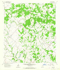
1963 Map of Kurten
USGS Topo · Published 1964About this map
The rural landscape of Brazos County in the early 1960s is defined by a dense network of family-named cemeteries and small community hubs. Small settlements like Kurten and Tabor serve as the primary anchors for this region, while names like Union, Bee, and Cottonwood mark localized clusters of activity. The area is heavily intersected by seasonal watercourses such as Wickson Creek and Mathis Creek, which weave through the prairie land. Genealogists will find particular value in the high density of burial sites documented here, including the Schultze Cem, Ebenezer Cem, and the Jim Harris Cem. These sites, alongside local landmarks like the Tabor Community Center and the Moore Sch, provide a clear picture of the social and family-based infrastructure that supported the Brazos valley farming communities before modern consolidation.
Find a feature on this map
43 named features on this map. Tap any name to fly to it.
Don’t see what you’re looking for? This feature index may not catch every label — zoom into the map to look around manually.
Map Details
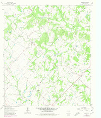
Editions of this 1963 Kurten Map
2 editions found
Other maps of this area

1925 · Iola No 2
USGS Topo · 1:48,000

1931 · Iola
USGS Topo · 1:62,500

1954 · Austin
USGS Topo · 1:250,000

1956 · Bryan
USGS Topo · 1:62,500

1956 · Carlos
USGS Topo · 1:62,500

1959 · Clear Lake
USGS Topo · 1:24,000

1959 · Reliance
USGS Topo · 1:24,000

1962 · Edge
USGS Topo · 1:24,000

1962 · Wheelock
USGS Topo · 1:24,000

1962 · Bryan East
USGS Topo · 1:24,000