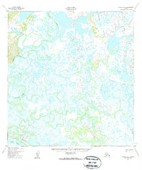
1952 Map of Kwiguk A-1
USGS Topo · Published 1959About this map
The Yukon River borders the southern edge of this landscape, serving as the primary drainage for a complex network of meandering waterways and wetlands. Based on aerial photography taken in 1951, the survey highlights the hydraulic character of the region, where the Chuilnak River and Kuyukutuk River twist through a low-lying terrain dominated by unnamed lakes and marshes. A seasonal overland route, the Winter Trail (Approximate), skirts the southern bank, reflecting the traditional transportation patterns of the Alaskan interior where frozen ground allows for movement between points.
Find a feature on this map
7 named features on this map. Tap any name to fly to it.
Don’t see what you’re looking for? This feature index may not catch every label — zoom into the map to look around manually.
Map Details
Editions of this 1952 Kwiguk A-1 Map
2 editions found
Other maps of this area

1947 · Russian Mission
USGS Topo · 1:250,000

1950 · Russian Mission
USGS Topo · 1:250,000

1951 · Marshall
USGS Topo · 1:250,000

1951 · Holy Cross
USGS Topo · 1:250,000

1952 · Kwiguk
USGS Topo · 1:250,000

1952 · Kwiguk B-2
USGS Topo · 1:63,360

1952 · Holy Cross B-6
USGS Topo · 1:63,360

1952 · Kwiguk A-2
USGS Topo · 1:63,360

1952 · Kwiguk A-1
USGS Topo · 1:63,360

1952 · Kwiguk B-1
USGS Topo · 1:63,360