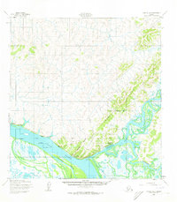
1952 Map of Kwiguk A-3
USGS Topo · Published 1973About this map
The Yukon River and its intricate network of sloughs dominate this 1952 landscape, where the Andreafsky River meets the larger waterway. The map documents the community of Andreafsky (St Marys PO) and the nearby St Marys Corporate Bdy, alongside older riverine settlements such as Old Andreafsky and Pitkas Point. The presence of a Winter Trail (Approximate) and a Landing Strip underscores the seasonal and aerial nature of transportation in this environment before modern road infrastructure.
Find a feature on this map
20 named features on this map. Tap any name to fly to it.
Don’t see what you’re looking for? This feature index may not catch every label — zoom into the map to look around manually.
Map Details
Editions of this 1952 Kwiguk A-3 Map
2 editions found
Other maps of this area

1951 · Marshall
USGS Topo · 1:250,000

1952 · Kwiguk
USGS Topo · 1:250,000

1952 · Kwiguk B-3
USGS Topo · 1:63,360

1952 · Kwiguk B-2
USGS Topo · 1:63,360

1952 · Kwiguk A-2
USGS Topo · 1:63,360

1952 · Kwiguk A-4
USGS Topo · 1:63,360

1952 · Kwiguk A-3
USGS Topo · 1:63,360

1952 · Kwiguk B-4
USGS Topo · 1:63,360

1952 · Marshall D-5
USGS Topo · 1:63,360

1952 · Marshall D-4
USGS Topo · 1:63,360
Featured Places
- Saint Mary's, St. Mary's
- Old Andreafsky, St. Mary's
- Pitkas Point, AK
- St. Mary's, AK
- Unorganized Borough, AK