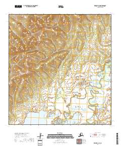
2018 Map of Kwiguk B-1 NE
USGS Topo · Published 2018About this map
Atchuelinguk River meanders through the southeastern corner of this landscape, representing the primary hydrological feature of this remote portion of the Kusilvak Census Area. The terrain transitions from high, contoured ridges in the northwest to expansive, saturated wetlands and low-lying plains in the south and east. This 2018 survey reveals an environment largely untouched by development, defined by the systematic township and range boundaries of t28n r70w and t27n r69w. The mapping of these vast marshes and elevation changes highlights the logistical challenges of the Alaskan interior, where natural drainage patterns dictate movement and settlement remains absent.
Find a feature on this map
7 named features on this map. Tap any name to fly to it.
Don’t see what you’re looking for? This feature index may not catch every label — zoom into the map to look around manually.
Map Details
Editions of this 2018 Kwiguk B-1 NE Map
This is the sole edition of this map. No revisions or reprints were ever made.
Other maps of this area

1951 · Holy Cross
USGS Topo · 1:250,000

1952 · Kwiguk
USGS Topo · 1:250,000

1952 · Holy Cross C-6
USGS Topo · 1:63,360

1952 · Holy Cross B-6
USGS Topo · 1:63,360

1952 · Kwiguk B-1
USGS Topo · 1:63,360

1952 · Kwiguk C-1
USGS Topo · 1:63,360

1952 · Holy Cross
USGS Topo · 1:250,000
2017 · Holy Cross B-6 SW
USGS Topo · 1:25,000
2017 · Holy Cross B-6 NW
USGS Topo · 1:25,000
2017 · Holy Cross C-6 SW
USGS Topo · 1:25,000