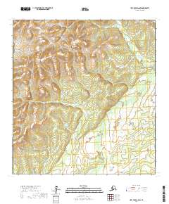
2017 Map of Holy Cross C-6 SW
USGS Topo · Published 2017About this map
Untouched Alaskan wilderness defines this 2017 survey of the Kusilvak region, where the terrain transitions from elevated ridges in the north to expansive wetlands in the south. The upper portion of the quadrangle, including T29n R68w and T29n R67w, is characterized by significant topographic relief, with several prominent hills reaching elevations over 1,000 feet. In contrast, the southern reaches spanning T28n R68w and parts of T28n R69w are dominated by a complex network of marshes and small water bodies. This map provides a detailed view of the Public Land Survey System divisions in a remote section of the Alaska-Kusilvak Census Area where no named settlements or roads are present, emphasizing the raw natural state of the landscape in the early 21st century.
Find a feature on this map
5 named features on this map. Tap any name to fly to it.
Don’t see what you’re looking for? This feature index may not catch every label — zoom into the map to look around manually.
Map Details
Editions of this 2017 Holy Cross C-6 SW Map
This is the sole edition of this map. No revisions or reprints were ever made.
Other maps of this area

1951 · Holy Cross
USGS Topo · 1:250,000

1952 · Kwiguk
USGS Topo · 1:250,000

1952 · Holy Cross C-6
USGS Topo · 1:63,360

1952 · Holy Cross B-6
USGS Topo · 1:63,360

1952 · Kwiguk B-1
USGS Topo · 1:63,360

1952 · Kwiguk C-1
USGS Topo · 1:63,360

1952 · Holy Cross
USGS Topo · 1:250,000
2017 · Holy Cross C-6 NW
USGS Topo · 1:25,000
2017 · Holy Cross C-6 SE
USGS Topo · 1:25,000
2017 · Holy Cross C-6 NE
USGS Topo · 1:25,000