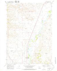
1969 Map of La Barge
USGS Topo · Published 1979About this map
La Barge serves as the focal point of this late-1960s survey, situated along the Green River near the border of Sublette and Lincoln Counties. The landscape is defined by the industrial development of the Big Piney-La Barge oil and gas fields, evidenced by a dense network of Oil Wells, Gas Wells, and a prominent Pipeline cutting through the western terrain. The river valley is a complex system of irrigation and navigation features, including Cowdell Island, the Water Waste Ditch, and the La Barge Landing Area near Whelan Bridge. The surrounding high desert is carved by deep drainages with distinctive names like Bird Nipple and Figure Four Canyon, while landmarks such as The Frog and Red Hill provide orientation for those navigating the arid mesas.
Find a feature on this map
27 named features on this map. Tap any name to fly to it.
Don’t see what you’re looking for? This feature index may not catch every label — zoom into the map to look around manually.
Map Details
Editions of this 1969 La Barge Map
3 editions found
Other maps of this area

1945 · Fort Hill
USGS Topo · 1:62,500

1947 · Fort Hill
USGS Topo · 1:62,500

1955 · Preston
USGS Topo · 1:250,000

1958 · Preston
USGS Topo · 1:250,000

1962 · Preston
USGS Topo · 1:250,000

1968 · Anderson Canyon
USGS Topo · 1:24,000

1968 · Names Hill
USGS Topo · 1:24,000

1969 · Chimney Butte
USGS Topo · 1:24,000

1969 · La Barge
USGS Topo · 1:24,000
1969 · Milleson Draw
USGS Topo · 1:24,000