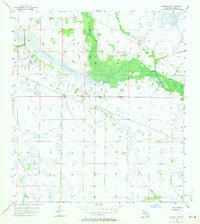
1958 Map of La Belle NW
USGS Topo · Published 1971About this map
Rainey Slough and the winding course of Fisheating Creek dominate this 1958 topographic survey of the Florida interior. The landscape is a complex network of seasonal waterways and wetlands, where the vast marshes of Chaparral Slough meet the defined channel of Bee Branch. Unlike more developed coastal regions, this area remains a landscape defined by natural drainage patterns and the subtle topography of the Glades. A few unimproved dirt tracks and section lines provide the only human imprint on a terrain that relies on the natural flow of these water bodies. Researchers and naturalists can trace the undisturbed 1950s hydrology of this region before modern water management significantly altered the flow of the inland Florida peninsula.
Find a feature on this map
6 named features on this map. Tap any name to fly to it.
Don’t see what you’re looking for? This feature index may not catch every label — zoom into the map to look around manually.
Map Details
Editions of this 1958 La Belle NW Map
3 editions found

Other maps of this area

1956 · Telegraph Swamp NE
USGS Topo · 1:24,000

1956 · West Palm Beach
USGS Topo · 1:250,000

1956 · Fort Pierce
USGS Topo · 1:250,000

1957 · West Palm Beach
USGS Topo · 1:250,000

1957 · Long Island Marsh SE
USGS Topo · 1:24,000

1957 · Venus
USGS Topo · 1:24,000

1957 · Venus SW
USGS Topo · 1:24,000

1957 · Telegraph Swamp SE
USGS Topo · 1:24,000

1958 · Fort Pierce
USGS Topo · 1:250,000

1958 · West Palm Beach
USGS Topo · 1:250,000