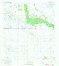
1958 Map of La Belle NW
USGS Topo · Published 1973About this map
Fisheating Creek meanders through this portion of the Florida interior, defining a landscape of complex drainage and seasonal wetlands. The survey, updated with 1973 photoview revisions, highlights a transition in land use within Glades County, where the expansive Rainey Slough and Chaparral Slough dominate the natural topography. These water systems illustrate the traditional sheet-flow drainage patterns of the region before significant modern alteration. While the area is primarily defined by its hydrology, including the northern reach of Bee Branch, the map also captures early grid-pattern developments and agricultural parcels emerging in the mid-20th century. This document provides a foundational look at the Glades County wilderness during a period of increasing human imprint on the native Florida landscape.
Find a feature on this map
6 named features on this map. Tap any name to fly to it.
Don’t see what you’re looking for? This feature index may not catch every label — zoom into the map to look around manually.
Map Details
Editions of this 1958 La Belle NW Map
3 editions found

Other maps of this area

1956 · Telegraph Swamp NE
USGS Topo · 1:24,000

1956 · West Palm Beach
USGS Topo · 1:250,000

1956 · Fort Pierce
USGS Topo · 1:250,000

1957 · West Palm Beach
USGS Topo · 1:250,000

1957 · Long Island Marsh SE
USGS Topo · 1:24,000

1957 · Venus
USGS Topo · 1:24,000

1957 · Venus SW
USGS Topo · 1:24,000

1957 · Telegraph Swamp SE
USGS Topo · 1:24,000

1958 · Fort Pierce
USGS Topo · 1:250,000

1958 · West Palm Beach
USGS Topo · 1:250,000