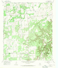
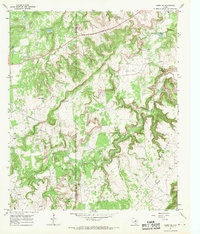
1967 Map of La Casa
USGS Topo · Published 1971About this map
The Stephens and Eastland county line crosses this 1967 survey of a landscape defined by petroleum extraction and ranching. An extensive Oil Field dominates the northern terrain, marked by dozens of individual Oil Wells and a network of unimproved roads and fine fence lines. The small community of La Casa serves as a central point, near the La Casa Valley Boys Ranch and the Mt Zion Cem. Transport history is visible along the Old Railroad Grade that runs south toward Bullock and Tiffin.
Find a feature on this map
24 named features on this map. Tap any name to fly to it.
Don’t see what you’re looking for? This feature index may not catch every label — zoom into the map to look around manually.
Map Details
Editions of this 1967 La Casa Map
2 editions found
Other maps of this area

1890 · Breckenridge
USGS Topo · 1:125,000

1894 · Eastland
USGS Topo · 1:125,000

1954 · Abilene
USGS Topo · 1:250,000

1958 · Abilene
USGS Topo · 1:250,000
1966 · Bear Mountain
USGS Topo · 1:24,000

1966 · Eastland
USGS Topo · 1:24,000

1966 · Ranger
USGS Topo · 1:24,000
1967 · Wayland
USGS Topo · 1:24,000

1967 · Necessity
USGS Topo · 1:24,000
1967 · Caddo NE
USGS Topo · 1:24,000