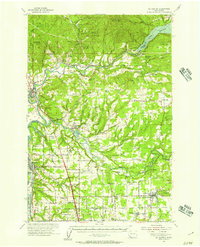
1954 Map of La Center
USGS Topo · Published 1957About this map
La Center and the East Fork Lewis River are central to this mid-century survey of Clark and Cowlitz counties. The landscape transitions from the river lowlands, where the Pacific Highway and multiple rail lines like the Great Northern serve the corridor, to the timbered heights of Green Mtn and Schumaker Mountain. A notable pattern of consolidation or rural shift is visible in the numerous educational landmarks marked as abandoned, such as Enterprise Sch and W Pioneer School, reflecting changes in local community structure as smaller schoolhouses gave way to larger districts like the High Sch in Battle Ground. Along the northern edge, Merwin Lake and the Cowlitz River demonstrate the region's managed waterways, supported by features like the State Fish Hatchery and a Gaging Sta near Ariel. For genealogists, several family and community burial grounds are documented, including Dublin Cem and Mtn View Cem.
Find a feature on this map
97 named features on this map. Tap any name to fly to it.
Don’t see what you’re looking for? This feature index may not catch every label — zoom into the map to look around manually.
Map Details
Editions of this 1954 La Center Map
2 editions found
Other maps of this area

1897 · Portland
USGS Topo · 1:62,500

1905 · Portland
USGS Topo · 1:62,500

1915 · Hillsboro
USGS Topo · 1:62,500

1918 · Hillsboro
USGS Topo · 1:62,500

1918 · Troutdale
USGS Topo · 1:62,500

1919 · Mount St Helens
USGS Topo · 1:125,000

1921 · Kalama
USGS Topo · 1:62,500

1922 · St. Helens
USGS Topo · 1:62,500

1934 · Troutdale
USGS Topo · 1:48,000

1940 · Hillsboro
USGS Topo · 1:62,500