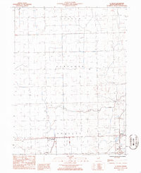
1986 Map of La Hogue
USGS Topo · Published 1986About this map
Illinois Central Gulf railroad tracks cut a decisive diagonal through this section of Iroquois County, anchoring the small settlement of La Hogue within Douglas township. The landscape is defined by the rectilinear precision of midwestern survey lines, interrupted only by the wandering course of Prairie Creek as it flows eastward toward the Gilman Corp Bdy. This 1980s-era survey captures the area's agricultural character, punctuated by specialized infrastructure like the Wilken Landing Strip and Kuiper Landing Strip, which reflect the intersection of traditional farming and private aviation. The map provides a clear view of township divisions including Ashkum and Danforth, offering a reliable record of property boundaries and rural development at the close of the twentieth century.
Find a feature on this map
10 named features on this map. Tap any name to fly to it.
Don’t see what you’re looking for? This feature index may not catch every label — zoom into the map to look around manually.
Map Details
Editions of this 1986 La Hogue Map
This is the sole edition of this map. No revisions or reprints were ever made.
Other maps of this area

1939 · Cissna Park
USGS Topo · 1:62,500

1944 · Piper City
USGS Topo · 1:48,000

1944 · Gilman
USGS Topo · 1:62,500

1946 · Gilman
USGS Topo · 1:62,500

1947 · Piper City
USGS Topo · 1:62,500

1948 · Buckley
USGS Topo · 1:62,500

1949 · Cissna Park
USGS Topo · 1:62,500

1949 · Buckley
USGS Topo · 1:62,500

1953 · Danville
USGS Topo · 1:250,000

1955 · Danville
USGS Topo · 1:250,000