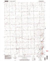
1998 Map of La Hogue
USGS Topo · Published 2003About this map
Ashkum, Danforth, and Douglas townships divide this section of Iroquois County, where the landscape is defined by the steady, geometric rhythm of the Public Land Survey System. The small settlement of La Hogue sits at a critical junction near the western edge of the map, while the larger center of Gilman occupies the southeastern corner. This area serves as a significant regional transportation hub, dominated by the Gilman Interchange where major regional thoroughfares converge. Beyond the structured road grid, the terrain is subtly marked by the winding path of Prairie Creek as it cuts across the southern townships. The presence of private aviation facilities like the Wilken Landing Strip and Kuiper Landing Strip suggests a landscape managed by large-scale agricultural interests during the late twentieth century.
Find a feature on this map
12 named features on this map. Tap any name to fly to it.
Don’t see what you’re looking for? This feature index may not catch every label — zoom into the map to look around manually.
Map Details
Editions of this 1998 La Hogue Map
This is the sole edition of this map. No revisions or reprints were ever made.
Other maps of this area

1939 · Cissna Park
USGS Topo · 1:62,500

1944 · Piper City
USGS Topo · 1:48,000

1944 · Gilman
USGS Topo · 1:62,500

1946 · Gilman
USGS Topo · 1:62,500

1947 · Piper City
USGS Topo · 1:62,500

1948 · Buckley
USGS Topo · 1:62,500

1949 · Cissna Park
USGS Topo · 1:62,500

1949 · Buckley
USGS Topo · 1:62,500

1953 · Danville
USGS Topo · 1:250,000

1955 · Danville
USGS Topo · 1:250,000