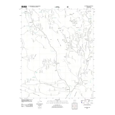
2011 Map of La Madera
USGS Topo · Published 2011About this map
Rio Vallecitos carves a path through the heart of this landscape, connecting the northern settlement of Vallecitos to La Madera in the south. The area is defined by its extensive mining history, with a high concentration of operations located along the Mesa de la Jarita and within the Cañon de los Alamos. These sites, including the Queen of Sheba Mine, Hidden Treasure Mine, and La Madera Fluorspar, suggest a rugged economy centered on mineral extraction in the early 21st century. Smaller residential clusters like Ancones and Vargas-Jaramillo are situated along the river valley, while established ranch sites such as Rancho de Trujillo and Rancho de Olguin dot the northern terrain. The confluence of the Rio Vallecitos and Rio Tusas near the southern quadrangle border highlights the drainage patterns that have historically shaped local settlement and transportation routes like Co RD 250.
Find a feature on this map
72 named features on this map. Tap any name to fly to it.
Don’t see what you’re looking for? This feature index may not catch every label — zoom into the map to look around manually.
Map Details
Editions of this 2011 La Madera Map
This is the sole edition of this map. No revisions or reprints were ever made.
Other maps of this area

1918 · Abiquiu
USGS Topo · 1:125,000

1918 · Tusas
USGS Topo · 1:125,000

1953 · Valle Grande Peak
USGS Topo · 1:24,000

1953 · El Rito
USGS Topo · 1:24,000

1953 · La Madera
USGS Topo · 1:24,000

1953 · Ojo Caliente
USGS Topo · 1:24,000

1954 · Raton
USGS Topo · 1:250,000

1954 · Aztec
USGS Topo · 1:250,000

1958 · Raton
USGS Topo · 1:250,000

1958 · Aztec
USGS Topo · 1:250,000