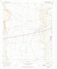
1954 Map of La Mesita Negra SE
USGS Topo · Published 1975About this map
Town Of Atrisco Grant and Pajarito Grant define the land ownership and survey boundaries of this New Mexico landscape west of Albuquerque. Surveyed in 1954 and updated with mid-1970s revisions, the map reveals a transition toward modern infrastructure atop traditional Spanish land grants. The high desert floor of El Rincon is punctuated by mid-century technological landmarks, including a CAA Beacon, a TV Tower, and a Radio Relay Tower. These structures, alongside the dual alignment of 66 40, demonstrate the corridor's role in regional communication and transportation. Evidence of localized industry appears through several Gravel Pits (Inactive) and an Oil Well (Aband), reflecting the extraction efforts that preceded later urban expansion into these mesas.
Find a feature on this map
12 named features on this map. Tap any name to fly to it.
Don’t see what you’re looking for? This feature index may not catch every label — zoom into the map to look around manually.
Map Details
Editions of this 1954 La Mesita Negra SE Map
4 editions found
Other maps of this area

1888 · Bernalillo
USGS Topo · 1:125,000

1889 · Albuquerque
USGS Topo · 1:125,000

1893 · Albuquerque
USGS Topo · 1:125,000

1934 · West Albuquerque
USGS Topo · 1:24,000

1934 · Griegos
USGS Topo · 1:24,000

1938 · Albuquerque
USGS Topo · 1:62,500

1952 · Wind Mesa
USGS Topo · 1:24,000

1952 · Isleta
USGS Topo · 1:24,000

1952 · Dalies NW
USGS Topo · 1:24,000

1954 · Volcano Ranch
USGS Topo · 1:24,000