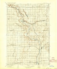
1918 Map of La Moure
USGS Topo · Published 1932About this map
The James River Valley dominates this early twentieth-century landscape, carving a serpentine path through the southeastern North Dakota prairie. This survey, revised by Herbert A. Hard in 1916, reveals a region defined by its rapid agricultural development and dense railroad network. The town of La Moure serves as a central hub where the Northern Pacific and the Fargo and Southwestern Br converge near the river's banks. To the south, Oakes appears as a critical junction for multiple lines, including the Chicago and Northwestern and the James River and Oakes Br. The map's township structure is clearly marked, showing established settlements like Grand Rapids, Berlin, and Verona. This period represents the peak of the small-town rail economy before the consolidation of rural post offices, capturing places like Glover, Clement, and Silverleaf at their height.
Find a feature on this map
68 named features on this map. Tap any name to fly to it.
Don’t see what you’re looking for? This feature index may not catch every label — zoom into the map to look around manually.
Map Details
Editions of this 1918 La Moure Map
2 editions found

Other maps of this area

1894 · Monango
USGS Topo · 1:62,500

1894 · La Moure
USGS Topo · 1:62,500

1894 · Ellendale
USGS Topo · 1:62,500

1894 · Hecla
USGS Topo · 1:62,500

1894 · Savo
USGS Topo · 1:62,500

1894 · Fullerton
USGS Topo · 1:62,500

1894 · Oakes
USGS Topo · 1:62,500

1895 · Lamoure
USGS Topo · 1:125,000

1896 · Columbia
USGS Topo · 1:125,000

1896 · Jamestown
USGS Topo · 1:125,000