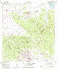
1952 Map of La Parra Ranch
USGS Topo · Published 1986About this map
La Parra Ranch serves as the central focal point of this coastal Kenedy County landscape, where the shifting sands of the Texas shore meet a specialized ranching economy dependent on artesian water. The map documents an extensive network of named water sources, such as Bordas Artesian Well, Mwalessos Artesian Well, and Padre Alijos Artesian Well, which provided the necessary lifeblood for livestock in this arid environment.
Find a feature on this map
20 named features on this map. Tap any name to fly to it.
Don’t see what you’re looking for? This feature index may not catch every label — zoom into the map to look around manually.
Map Details
Editions of this 1952 La Parra Ranch Map
3 editions found
Other maps of this area

1928 · Sarita
USGS Topo · 1:125,000

1950 · Corpus Christi
USGS Topo · 1:250,000

1951 · Kleberg Point
USGS Topo · 1:24,000

1951 · Sarita 4 NE
USGS Topo · 1:24,000

1952 · Riviera Beach
USGS Topo · 1:24,000

1952 · La Parra Ranch
USGS Topo · 1:24,000

1952 · Sarita 4 SE
USGS Topo · 1:24,000

1952 · Riviera Beach
USGS Topo · 1:62,500

1954 · La Parra Ranch SW
USGS Topo · 1:24,000

1954 · Sarita
USGS Topo · 1:62,500