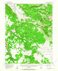
1954 Map of La Sal Junction
USGS Topo · Published 1963About this map
Spanish Valley and the northern reaches of the La Sal Mountains dominate this mid-century survey of the Utah canyonlands. The landscape transitions from the high peaks of Mt Tukuhnikivatz down into the complex drainage networks of Pack Creek and Coyote Wash. The map documents a period of early infrastructure and resource extraction, marked by the Grand County Airport near the border of Grand and San Juan counties and the scattered prospects and Yellow Circle Mines found along the canyon rims.
Find a feature on this map
53 named features on this map. Tap any name to fly to it.
Don’t see what you’re looking for? This feature index may not catch every label — zoom into the map to look around manually.
Map Details
Editions of this 1954 La Sal Junction Map
4 editions found

Other maps of this area

1885 · La Sal
USGS Topo · 1:250,000

1954 · Mt Peale 3 NW
USGS Topo · 1:24,000

1954 · Mt. Waas 4 SW
USGS Topo · 1:24,000

1954 · Mt Peale 4 NW
USGS Topo · 1:24,000

1954 · Mt Peale 3 NE
USGS Topo · 1:24,000

1954 · Mt Peale 1 SW
USGS Topo · 1:24,000

1954 · Mt Peale 1 NW
USGS Topo · 1:24,000

1954 · Mt Peale 2 SW
USGS Topo · 1:24,000

1954 · Mt Peale 2 NW
USGS Topo · 1:24,000

1954 · Mt Peale 2 SE
USGS Topo · 1:24,000