
1956 Map of La Sal Vieja
USGS Topo · Published 1958About this map
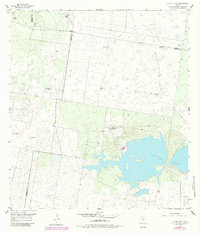
La Sal Vieja dominates this portion of the Rio Grande Valley, where hypersaline waters and scattered depressions define the brushy landscape of South Texas. During the mid-1950s, this area at the intersection of Hidalgo, Kenedy, and Willacy Counties was characterized by a transition from traditional ranching to early energy extraction. The map documents numerous family-named landmarks and infrastructure essential for survival in this arid environment, including the San Leonardo Windmill, Juan Barrientos Windmill, and the Stillman Windmill.
Find a feature on this map
20 named features on this map. Tap any name to fly to it.
Don’t see what you’re looking for? This feature index may not catch every label — zoom into the map to look around manually.
Map Details
Editions of this 1956 La Sal Vieja Map
2 editions found
Other maps of this area

1922 · La Sal Vieja
USGS Topo · 1:62,500

1939 · Linn
USGS Topo · 1:62,500

1949 · Mc Allen
USGS Topo · 1:250,000

1953 · Brownsville
USGS Topo · 1:250,000

1954 · McAllen
USGS Topo · 1:250,000

1956 · Rudolph
USGS Topo · 1:24,000

1956 · Andrea Ranch
USGS Topo · 1:24,000

1956 · Yturria
USGS Topo · 1:24,000
1956 · Raymondville
USGS Topo · 1:24,000

1956 · La Sal Vieja
USGS Topo · 1:62,500