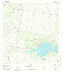
1956 Map of La Sal Vieja
USGS Topo · Published 1984About this map
La Sal Vieja, a salt lake in the South Texas brush country, dominates this landscape at the intersection of Kenedy, Hidalgo, and Willacy counties. The area is characterized by a network of ranching infrastructure, primarily a high concentration of named windmills that serve as vital landmarks across the arid terrain. Key locations include the San Jose de los Llanos Windmill, Jesus Maria Windmill, and La Tordilla Windmill, reflecting the deep-rooted Hispanic ranching heritage of the Rio Grande Valley hinterlands. Near the shore of the lake, La Sal Vieja Ranch stands alongside a Pumphouse and several Spoil Banks, while a small Landing Strip to the north indicates the region's mid-century reliance on private aviation for managing remote property. To the west, the landscape transitions from natural salt flats to industrial utility with several Gas Wells and an Artesian Well.
Find a feature on this map
22 named features on this map. Tap any name to fly to it.
Don’t see what you’re looking for? This feature index may not catch every label — zoom into the map to look around manually.
Map Details
Editions of this 1956 La Sal Vieja Map
2 editions found
Other maps of this area

1922 · La Sal Vieja
USGS Topo · 1:62,500

1939 · Linn
USGS Topo · 1:62,500

1949 · Mc Allen
USGS Topo · 1:250,000

1953 · Brownsville
USGS Topo · 1:250,000

1954 · McAllen
USGS Topo · 1:250,000

1956 · Rudolph
USGS Topo · 1:24,000

1956 · Andrea Ranch
USGS Topo · 1:24,000

1956 · La Sal Vieja
USGS Topo · 1:24,000

1956 · Yturria
USGS Topo · 1:24,000
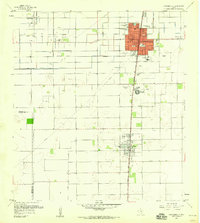
1956 · Raymondville
USGS Topo · 1:24,000