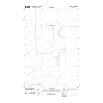
2010 Map of La Salle Lake
USGS Topo · Published 2010About this map
The Mississippi River meanders through this Clearwater County landscape, carving a serpentine path west of a chain of significant water bodies including Big LaSalle Lake, Middle LaSalle Lake, and LaSalle Lake. This 2010 survey documents a largely rural area characterized by its hydrology and small-scale settlements like Vern and the riverfront Coffee Pot Landing. Genealogists and local historians will find value in the placement of the Sell Lake Cemetery and Old Sell Lake Cemetery, which speak to the community's early residents and the shifts in local burial grounds over time. The presence of the LaSalle Lookout Tower emphasizes the importance of timber and fire management in this northern Minnesota terrain. Moving south, the map reaches the northern boundary of Lake Itasca, where Sucker Creek feeds into the glacial headwaters region, illustrating the intricate network of streams and creeks like Bear Creek that define the local watershed.
Find a feature on this map
29 named features on this map. Tap any name to fly to it.
Don’t see what you’re looking for? This feature index may not catch every label — zoom into the map to look around manually.
Map Details
Editions of this 2010 La Salle Lake Map
This is the sole edition of this map. No revisions or reprints were ever made.
Other maps of this area

1954 · Bemidji
USGS Topo · 1:250,000

1957 · Bemidji
USGS Topo · 1:250,000

1958 · Bemidji
USGS Topo · 1:250,000

1969 · Anchor Hill
USGS Topo · 1:24,000

1969 · Heart Lake
USGS Topo · 1:24,000
1969 · Upper Rice Lake
USGS Topo · 1:24,000

1972 · Alida
USGS Topo · 1:24,000

1972 · La Salle Lake
USGS Topo · 1:24,000
1972 · Grant Lake
USGS Topo · 1:24,000
1972 · Lake Itasca
USGS Topo · 1:24,000